
 SURVEY
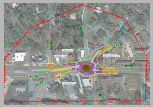
Platinum Geomatics (PG) was contracted to perform professional land surveying services for a proposed roundabout encompassing approximate 20-acres located in Clarke County, GA for the Athens-Clarke County Government.
PG staff created a GDOT compliant primary control package for this project. After the control was in place the staff utilized our Leica RTC 360 terrestrial scanner to collect terrestrial LiDAR of the entire project survey boundary. The scans were controlled and calibrated into a comprehensive point cloud. The PG mapping technicians extracted all topographic and planimetric features visible in the point cloud.
 MULTIPLE SERVICES
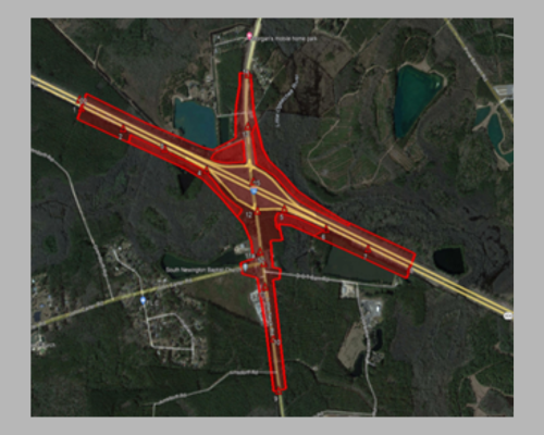
Platinum Geomatics (PG) was contracted by VHB, Inc. for the project improving existing Chevis Road from SR 25 to Wild Heron Road in Chatham County. The improvements include pedestrian and bicycle facilities, drainage improvements, and intersection analysis. PG provided a survey database, SUE QL-C, and special studies.
PG prepared the Survey Control Package and collected all information required in the GDOT Survey Manual. During the Special Studies phase of the project, PG developed a utility composite (UTLE) by contacting utility owners and collecting utility record information, performed CADD operations to draw, label, and place cells of collected information in MicroStation format according to the current version of the GDOT EDG.
 MULTIPLE SERVICES
Platinum Geomatics (PG) was contracted by VHB, Inc. and focused on the interchange of Interstate 16 and Little Neck Road (Bloomingdale Road) in Chatham County. The project centerline totals approximately 1.5 miles in length along I-16 and 1.2 miles along Little Neck / Bloomingdale Road including sideroads and on/off ramps. The area covered by this survey totals approximately 2.7 miles of mainline and 164 acres.
PG deployed its Unmanned Aerial Vehicle (UAV) DJI M600 Pro equipped with a TrueView 635 3D Imaging System and Riegl miniVUX3 LiDAR Laser Scanner. During the Special Studies phase of the project, PG developed a utility composite (UTLE) by contacting utility owners and collecting utility record information, performed CADD operations to draw, label, and place cells of collected information in MicroStation format according to the current version of the GDOT EDG.
 AERIAL MAPPING
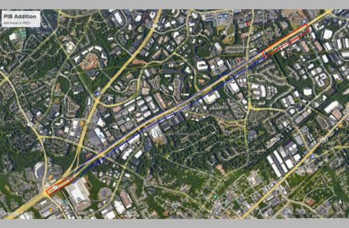
Platinum Geomatics (PG) was contracted by Precision Planning, Inc. (PPI) to perform professional aerial imagery, LiDAR, and photogrammetric services to facilitate the design required to widen +/- 2.3 miles of Peachtree Industrial Boulevard (PIB) from Jimmy Carter Boulevard to Medlock Bridge Road.
PG initiated an aerial data collection mission utilizing low-altitude aerial LiDAR and ground sample distance (GSD) aerial imagery. This aerial mission provided the source data to develop a thorough planimetric and topographic survey of the project corridor
 UTILITY COORDINATION
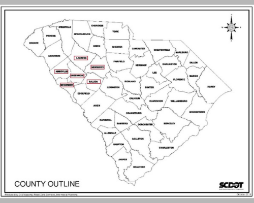
This design-build project included the replacement and utility coordination of 16 bridges across District 2 in Abbeville, Greenwood, Laurens, McCormick, Newberry, and Saluda counties in South Carolina.
Each of the 16 bridges were replaced including the associated roadway and drainage work necessary to tie the new approaches to the existing roadways. The project included the demolition, removal, and disposal of the existing bridge structures. PG staff coordinated with all utility companies of the proposed design or construction required for the relocation of any utilities either due to a physical conflict or crane safety clearances.
 SURVEY
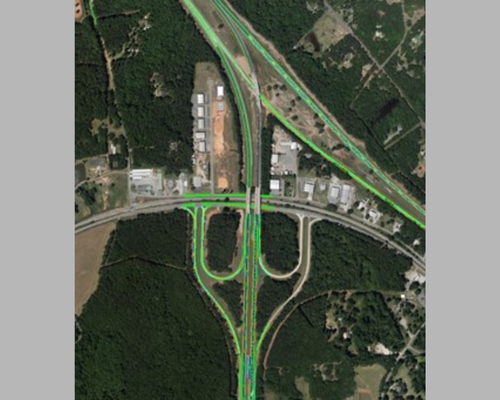
The I-285 Eastside Express Lanes project was designed to add one optional, buffer-separated express lane in each direction on I-285 between I-20 and Henderson Road in DeKalb County.
PG’s Team provided the following services on this project: Topographic Survey, Property Research, Boundary Survey, Tax Map & Deed Research, Right-of-Way, Railroad Surveys, Channel Hydraulic Surveys, Surface Utility Surveys, Bridge Surveys
 AERIAL MAPPING
Platinum Geomatics (PG), as part of the design team lead by RS&H, Inc. was tasked with photo control and aerial imagery & LiDAR acquisition and photogrammetric mapping of Georgia Department of Transportation’s (GDOT) Major Mobility Investment Program’s (MMIP) Interstate 75 Commercial Vehicle Lane (CVL) project.
This project consists of approximately 42 miles of interstate highway beginning just north of Macon, GA at the intersection of I-75 and I-475 in Monroe County proceeding north to State Route 155 in Henry County, GA. The photo control was comprised of establishing painted aerial panels along the shoulder at 1,000′ intervals with vertical check shots taken at the mid-point between each panel. The aerial imagery and LiDAR were collected at 0.25′ pixel resolution for the imagery and the LiDAR point cloud consisted of twenty points per meter (20 ppm) data.
 SUBSURFACE UTILITY ENGINEERING (SUE)
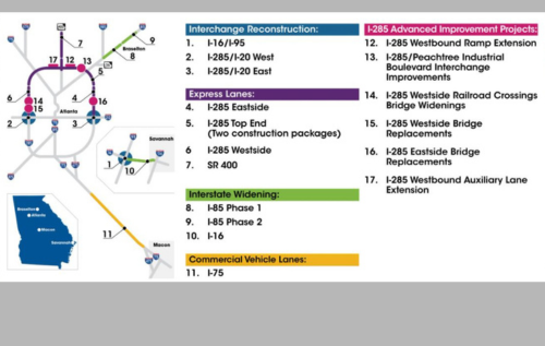
The project includes barrier separated Express Lanes (ELs) in each direction along 180 miles of I-285 from just south of Paces Ferry Road (Exit 18) to Henderson Road and along 3.5-miles of SR 400 from south of the Glenridge Connector to the vicinity of the MARTA North Springs Station. Being constructed in two phases the I-285 Top End West section includes ELs in both directions from Paces Ferry Road (Exit 18) to SR 400. The I-285 Top End East section includes ELs in both directions from Henderson Road to SR 400 and along SR 400 from south of Glenridge connector north to the MARTA North Springs Station. System-to-System connections are with existing EL systems at I-75 Northwest Corridor (NWC) and at I-85 ELs.
PG staff performed Quality Level B SUE investigation to include: 30 Utility Owners, 338 Utility Poles, 175,084 L/F Underground Utility Lines (excludes sanitary sewer gravity lines), 93 Sanitary Gravity Sewer Manholes, 19,620 L/F Sanitary Sewer Gravity Lines
 SURVEY
Platinum Geomatics (PG) conducted a boundary and topographic survey of the entire boundary of the subject project site estimated at 771.80 acres. This survey also included all internal boundary lines as this site was subdivided for further development under the project code name, Morning Hornet.
The external and internal boundary lines totaled approximately 46,500 linear feet of traverse. In addition to these boundary line surveys, PG field staff surveyed approximately 12,600 linear feet of transects, These profile lines were utilized to enhance and verify existing aerial LiDAR data of the site.
 AERIAL MAPPING
Platinum Geomatics (PG) photogrammetric staff selected photo-identifiable ground control points around the perimeter of the 950-acre site as well as several vertical control check points internal to the site boundary.
Staff utilized 0.5′ pixel aerial imagery and ten (10) points per meter LiDAR data collected from a helicopter platform to accurately map the site. The ground control collected was used to calibrate the LiDAR point cloud in conjunction with the Airborne GPS and Inertial Measurement Unit (IMU) data recorded during the flight. After acceptable calibration (RMSE) was achieved, the LiDAR data was post-processed to a bare-earth surface and hydrographic break lines collected to accurately depict the topography of the corridor. This Digital Terrain Model (DTM) was utilized to produce two-foot contours within the outlined boundary. The density of the point cloud coupled with the break lines collected from the LiDAR data produced specific detail to the DTM to ensure accurate representation of the terrain.
Planimetric data to include all above ground utilities, edges of pavement, building outlines, tree lines, fences, signs, and other miscellaneous features as visible and identifiable from the photography were collected and provided.
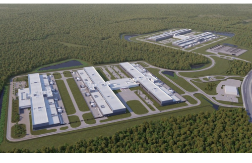
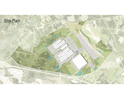
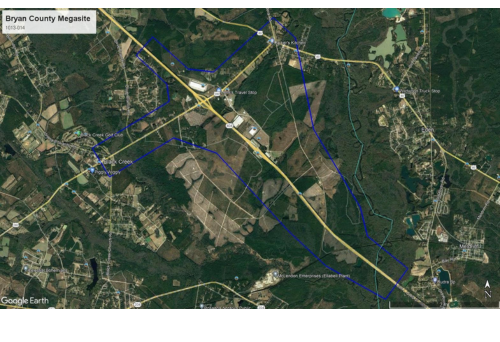 MULTIPLE SERVICES
Platinum Geomatics was contracted to provide land surveying, aerial photogrammetry, aerial mapping, right-of-way staking, and subsurface utility engineering (SUE) services for the 2,923-acre site purchased jointly by the Savannah Harbor-Institute 16 Corridor Joint Development Authority (JDA) and the State of Georgia.
PG staff supported survey database, survey control, LiDAR aerial mapping database, preliminary utility plans, and utility coordination for obscured areas, observable utilities, and drainage. To complete this task, PG staff utilized OpenRoads Designer in accordance with current GDOT guidelines. PG staff established right-of-way plans research, utility coordination, and SUE and completed a utility relocation cost estimate.
 SURVEY
Platinum Geomatics (PG) provided all ground control and calibration for an aerial LiDAR project conducted for the United States Geological Survey (USGS) in support of their 3D Elevation Program (3DEP) on this project covering approximately 32,690 square miles total land area in Georgia. PG field staff established x, y, and z coordinates for 547 non-vegetated vertical assessment points, 373 vegetated vertical assessment points and 326 ground control points with a total point count of 1,246 GPS points observed.
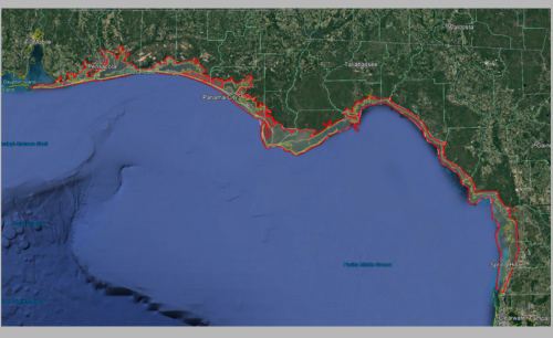
SURVEY
Platinum Geomatics (PG) provided ground survey support for the NOAA Coastal Mapping Program to include: Forty (40) Ground Control Point Clusters (30 points per cluster), 190 NVA/WA Check Points, 65 Air Target Points used to support imagery processing, Bathy/Turbidity Checkpoints (15 points per location), PG used GPS technology and the local VRS network to establish x, y, z and coordinated for forty (40) ground control points evenly distributed throughout the project area.
In addition to the point data, PG staff took pictures of each point as it was being observed and these pictures were included as part of an overall control report and made part of the final deliverable.
 SURVEY
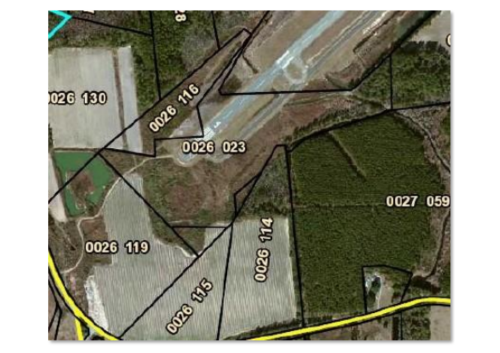
Platinum Geomatics (PG) was contracted to provide professional land surveying services of the subject site in Adel-Cook County, GA.
PG office staff researched and verified tax records and then field crews were mobilized to the Adel-Cook County Airport to field locate the property corners and cross surveyed the flood plain. With the field information, staff developed a geo-referenced CADD file as the deliverable.
 AERIAL MAPPING
PG office staff utilized aerial imagery, ground control, and an aero triangulation (AT) solution as provided by Jviation and Quantum Spatial to develop an autocorrelated Digital Elevation Model (DEM) of each of the eleven (11) airports. In addition, stereocompilation techniques to collect landmark features and major break lines.
Airports included in this project: Cook County, Covington, Polk County, Dr. CP Savage, Moultrie, Kaolin, Washington-Wilkes, Donalsonville, Burke County, Claxton, and Plantation Airpark
 SURVEY
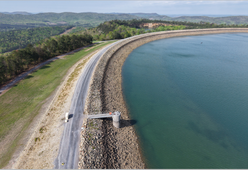
Platinum Geomatics (PG) under a General Services Agreement with Oglethorpe Power Corporation performs annual deformation and deflection monitoring surveys at the Rocky Mountain Pumped-Storage Hydroelectric facility. PG utilities GNSS systems, differential leveling, robotic total stations, and terrestrial LiDAR to ensure accuracy in these high-precision surveys.
PG has performed this survey in consecutive years since its founding in 2016.
 AERIAL MAPPING
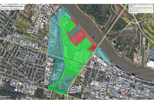
Platinum Geomatics (PG) was contracted to perform aerial photogrammetric services and survey enhancements on the approximately 325-acre site in Savannah, GA for the Georgia Ports Authority.
The site was flown utilizing LiDAR technology from an aerial platform to develop a point cloud of a minimum of twenty (20) points per meter. PG photogrammetric staff selected twelve (12) photo-identifiable ground control points around the perimeter of the site. These point locations were surveyed in the field by PG survey field staff and used as ground control and calibration of the mapping. The survey team mobilized to the site to complete survey data collection for features that were unidentifiable from aerial imagery.
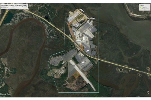 AERIAL MAPPING
Platinum Geomatics (PG) was contracted to perform aerial photogrammetric services and survey enhancements on the approximately 90-acre site in Brunswick, GA for the Georgia Ports Authority.
The site was flown utilizing LiDAR technology from an aerial platform to develop a point cloud of a minimum of twenty (20) points per meter. Simultaneously, imagery was captured at 0.25′ ground sample distance (GSD). PG photogrammetric staff selected thirty (30) photo-identifiable ground control points around the perimeter of the site. These point locations were surveyed in the field by PG survey field staff and used as ground control and calibration of the mapping. The survey team mobilized to the site to complete survey data collection for features that were unidentifiable from aerial imagery.